BEST applauds Lane County’s first Bicycle Master Plan; comment on draft through May 3
BEST applauds Lane County’s first Bicycle Master Plan (BMP) as the critical first step towards making bicycling safe and practical countywide. Building on an ambitious but compelling vision, the plan sets forth goals, identifies a countywide bicycle network, selects bikeway facilities to build out the network, divides these into discrete projects, and prioritizes these as near-, medium-, or long-term.
Through May 3, Lane County is accepting comments on this draft plan for rural roads and paved paths outside of the Eugene-Springfield urban area.
Then county commissioners will consider amending the Lane County Transportation System Plan (TSP) to incorporate the bicycle network detailed in the plan.
Below we summarize what we see as key elements of the plan.
Vision
Released in April 2022, the draft Bicycle Master Plan (BMP) starts with an ambitious but compelling vision (see page 18):
“Bicycling is a viable regional transportation option throughout Lane County for people of all ages and abilities, linking communities to destinations and services, and connecting where we live, work, and play.“
Goals
In exploring how to advance the vision, the plan is guided by six goals:
- Safety and Comfort
- Regional Connectivity
- Equitable and Inclusive Access
- Economic Vitality
- Environment and Quality of Life
- Feasibility
Each goal is elaborated by a series of more specific objectives. (See pages 18–20.)
Recommendations
The BMP is Lane County’s framework for amending the existing 2017 Transportation System Plan (TSP) to be in compliance with Oregon’s planning regulations, which call for a network of bicycle facilities in the public right-of-way (ROW). Oregon’s Transportation Planning Rule (TPR), OAR 660-012-0020(2)(d), requires that bikeways be provided along major County roadways, including arterials and major collectors. While these roads may currently not be the most comfortable routes for those on bicycles, they are often the most direct routes between Lane County’s communities and can therefore provide transportation function and serve people who lack other transportation options.
Other transportation routes, such as off-road paths and more indirect on-road routes preferred by recreational cyclists, are important and recognized by the BMP but remain second to bicycle routes that provide a direct transportation and utilitarian function. Thus, the BMP focuses on providing Lane County with better direction about how to prioritize limited resources to make investments where there are the greatest needs and demands for bicycling infrastructure in the public right-of-way. (See page 15.)
In order to develop a network of bicycle facilities that adequately serve Lane County’s communities, a four-step process was used to arrive at a prioritized list of projects (see page 51):
- Network: Selecting the routes that comprise Lane County’s bicycle network.
- Facilities: Determining the appropriate bikeway facilities on the bicycle network routes.
- Projects: Dividing the routes into projects.
- Priorities: Analyzing all projects to determine near-term, medium-term, and long-term project implementation.
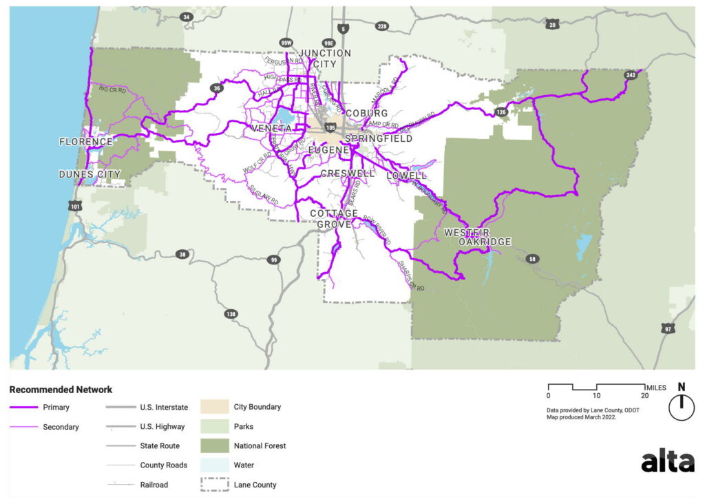
Network Recommendation
The first step was to select the routes that comprise Lane County’s bicycle network. These include primary and secondary routes. (See pages 52–53.)
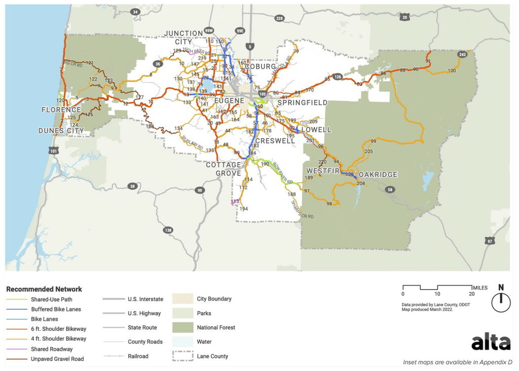
Facilities Recommendation
The second step was to determine the appropriate bikeway facilities on the bicycle network routes. These include (see pages 54–57):
- Buffered and Protected Bike Lanes: 56 miles
- Bike Lanes: 4 miles
- Shared-Use Paths (SUPs): 12 miles
- Shoulder Bikeways: 926 miles
- Shared Roadways: 18 miles
- Unpaved Gravel Roads: 99 miles
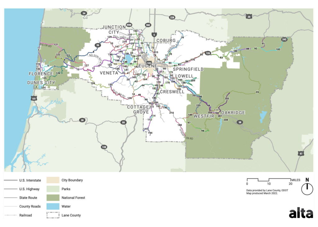
Projects Recommendation
The third step was to divide bikeway facilities into discrete projects (see pages 61–62).
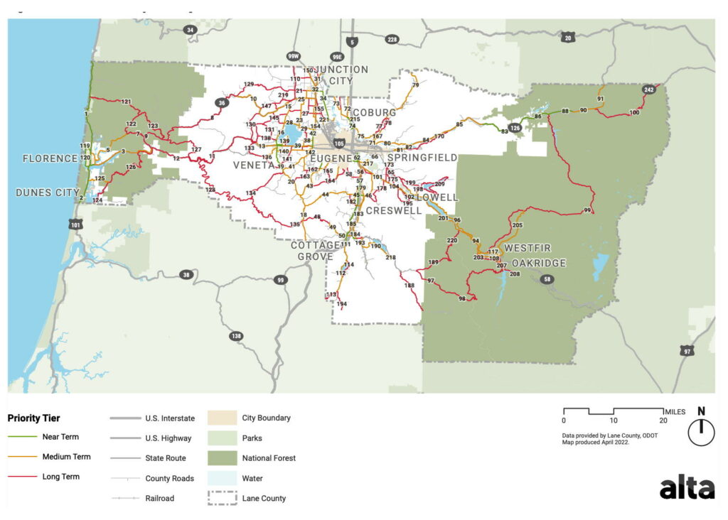
Priorities Recommendation
Finally, the fourth step was to assign priorities to each project (see pages 63–65):
- Near-term projects are those scheduled for implementation within 1–5 years
- Medium-term projects are those scheduled within a 5–10 year timeframe
- Long-term projects are those scheduled within a 10–20 year timeframe
Next Steps
The recommendation of a Bicycle Network is the first of many steps toward implementation and realization of the BMP’s vision. Orchestrating these improvements will require actions such as coordination between jurisdictions, cost assessment and funding, planning and detailed design, and measurement of network progress over time. In order to help make the Bicycle Network a reality, the BMP also includes information on implementation strategies, including design standards, funding resources, action steps, and performance measures.
Immediate next steps for the Lane County BMP include (see page 11):
- Adopting TSP Amendments
- Securing additional funding and resources to support project implementation including
- Advancing planning studies
- Refining and developing near-term projects
- Coordinating with local and state agencies
Notice from Lane County
The draft Bicycle Master Plan (BMP) is the product of a two-year process involving extensive technical analysis and community input. Data about community demographics, bicycle crashes and travel demand were foundational to identifying areas of vulnerability and need. The data was supplemented with local knowledge from a broad cross-section of stakeholders, community members, and partners from different sectors.
The planning framework and recommendations were reviewed by a Technical Advisory Committee consisting of representatives from seven cities, Travel Lane County, Oregon Department of Transportation, U.S. Forest Service, Lane Education Service District, and more. The public involvement process included stakeholder interviews with community-based organizations, two online public open houses, and survey responses from over 2,500 people. The plan reflects community needs and priorities for improving bicycling conditions, particularly as a transportation option outside of the Eugene/Springfield urban core.
The plan focuses on providing Lane County with better direction about how to prioritize limited resources to make investments where there are the greatest needs and demands for bicycling investments along public roads. Rural roads are not generally the most comfortable routes for people bicycling. However, they are the most direct routes between Lane County’s communities and can serve an important transportation need for people who lack access to a vehicle. Other transportation routes, such as off-road paths and more indirect on-road routes preferred by recreational cyclists, are important but remain second to bicycle routes that provide a direct transportation and utilitarian function.
The plan recognizes the importance of off-road routes by recommending a list of future studies, including a Lane County Trails Plan. The predominant recommendation of the plan is shoulder widening, to create a separate travel space for people bicycling on rural roads identified as part of a bicycle network. The bicycle network and project recommendations include facilities owned by Lane County and other agencies, such as Oregon Department of Transportation, cities, and the U.S. Forest Service.
Both the study projects and the shoulder widening projects, along with the bicycle network map, and policy amendments to support implementation of the BMP will be incorporated into Lane County’s Transportation System Plan (TSP) as an amendment. The TSP amendment process is scheduled for summer 2022 which will include public hearings before the Lane County Planning Commission and Board of County Commissioners. Stay tuned for the announcement of hearing dates.
In the meantime, all are invited to view the draft plan. Comments and questions submitted by May 3, 2022, will be evaluated prior to finalization of the BMP for the TSP amendment process. Please direct questions and comments to Becky Taylor, Senior Transportation Planner, Lane County Public Works at becky.taylor@lanecountyor.gov or by calling 541-682-6932.
Applicable legal requirements
Oregon’s Transportation Planning Rule (TPR) provides, in part:
660-012-0000: Purpose …
(1) This division implements Statewide Planning Goal 12 (Transportation) to provide and encourage a safe, convenient and economic transportation system. This division also implements provisions of other statewide planning goals related to transportation planning in order to plan and develop transportation facilities and services in close coordination with urban and rural development. The purpose of this division is to direct transportation planning in coordination with land use planning to: …
(c) Provide for safe and convenient vehicular, transit, pedestrian, and bicycle access and circulation; …
660-012-0020: Elements of Transportation System Plans …
(2) The TSP shall include the following elements: …
(d) A bicycle and pedestrian plan for a network of bicycle and pedestrian routes throughout the planning area. The network and list of facility improvements shall be consistent with the requirements of ORS 366.514; …
Further reading
- Lane County rolls out Bicycle Master Plan for rural areas (KLCC, 4/27/22)
- ‘We don’t have a blank check’: Lane County releases draft of unfunded bicycle master plan (Register-Guard, 4/26/22)
External links
- Bicycle Master Plan (BMP) (Lane County)
- Resources
- Draft Bicycle Master Plan (4/15/22)
- Draft Bicycle Master Plan Appendices (4/13/22)
- Draft Bicycle Network Map (9/30/21)
- Implementation Strategy Memo (10/20/21)
- Policies, Practices, and Programs Memo (9/30/21)
- Guiding Framework (3/15/21)
- Existing Conditions Memo (2/24/21)
- Fact Sheet (Sept. 2020)
- Photo Share
- Technical Advisory Committee Members
- Frequently Asked Questions
- Resources
- Transportation System Plan (TSP) (Lane County)